


The Bomber That Hit the Hill: Newfoundland’s Cold War Tragedy


It was March 18, 1953. Sleet was slashing across Burgoyne’s Cove. The Atlantic was the color of gunmetal. Somewhere above the waves, slicing through freezing fog just 1,000 feet off the water, a U.S. Air Force RB-36H Peacemaker bomber was flying blind — with no idea it was already over land.
Then, at 4:10 AM Newfoundland time, the ground reached up and ripped the plane apart.
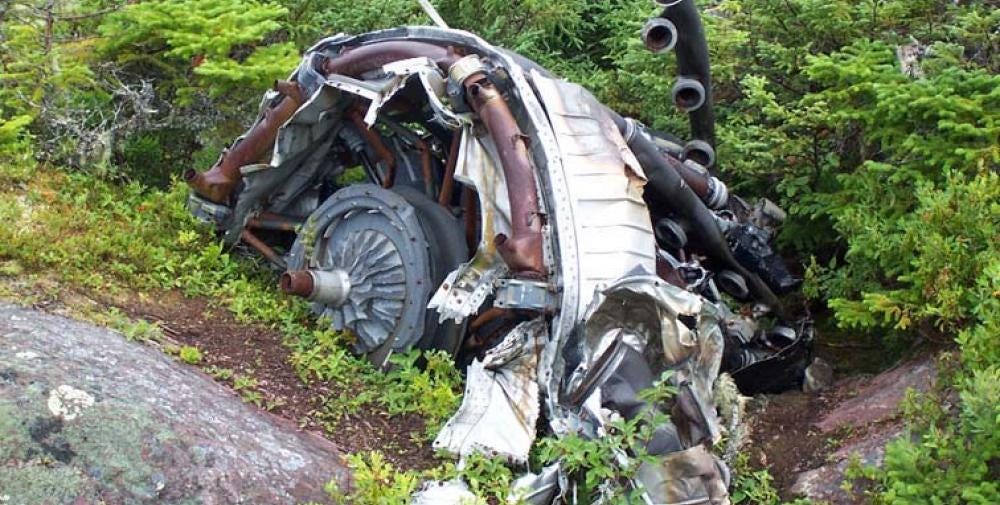
Six propellers shaved pine trees clean off the ridge. The left wing hit first. Fuel exploded. The fuselage disintegrated. Wreckage scattered across ¾ of a mile. The fire lit the hillside like a second sunrise.
All 23 men aboard were killed instantly.
And for decades, this story was mostly left to rot with the aluminum in the trees.
The Flight That Wasn’t Supposed to End Here
The plane was RB-36H #51-13721, flying for the 28th Strategic Reconnaissance Wing (Heavy). It lifted off at 0000 Zulu from Lajes Airdrome in the Azores, bound for Rapid City Air Force Base, South Dakota — later renamed Ellsworth AFB to honor the man who died in the crash.
Onboard were:
Capt. Jacob Pruett Jr.
Capt. Orion Clark
Brigadier General Richard Ellsworth
Major Frank Wright
And 19 others, including pilots, engineers, radio ops, and airmen
Officially, it was a “training mission.” But the aircraft was equipped with electronic reconnaissance gear — Cold War-speak for classified surveillance tech. The plane was designed to skirt enemy borders, pick up radar signals, and map terrain. But this wasn’t a combat run. It was supposed to be simple. Routine.
It was anything but.
Misread Sky. Misread Earth. Doomed Flight.
Here’s what went wrong:
The flight crew expected headwinds, but instead hit tailwinds — pushing them 1.5 hours ahead of schedule.
They were supposed to climb to a safe altitude 20 miles before landfall. But they thought they were still over open ocean.
Their radar — meant to scan for land — was never turned on.
Visibility was less than ⅛ mile in fog, sleet, and freezing drizzle.
The aircraft was flying straight and level at low altitude — like a ghost across black water.
Only they weren’t over water anymore.
At 0740 Zulu, just 30 miles past the Newfoundland coastline, the RB-36H slammed into an 896-foot ridge at 800 feet elevation.
Keep reading with a 7-day free trial
Subscribe to The Newfoundland History Sleuth to keep reading this post and get 7 days of free access to the full post archives.